Cochin Fm
Type Locality and Naming
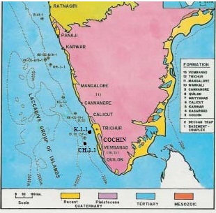
SUBSURFACE: The type section is in the Well CH-1-1, Interval is 3150-3942 m and thickness is 792 m. [Original Publication: Mathur, R.B., Sreekantswamy, H.N., Ananthakrishna, K., Srivatsava, U.C., Biswas, S.K., Krishna, A., Bhosale, J.S., Rao, K.V.N., Satyanarayana, Y., Rathod, G.D., Bose, P.K., and Karwal, S. 1993: Lithostratigraphy of Indian Petroliferous Basins, Document VI, Kerala Konkan Basin, KDMIPE, ONGC Publication, pp 1-33.]
Reference well: K-1-1, Interval is 802-1770m and thickness is 968 m. (refer location map under type section for figure)
[Figure 1: Location map of type section (after J.Mishra in Raju and Misra, 2009)]
Lithology and Thickness
Calcareous sandstone. The first phase of marine sedimentation in the Kerala - Konkan Basin is marked by about 730 m of Late Cretaceous sediments of Santonian to Maastrichtian age (Mittal, 1988) in the well CH-A-A which overlies the basaltic basement. The facies are mainly calcareous sandstone and siltstone, claystone, minor shale, arenaceous wackestone/ packstone and thin intrusives.
Five Cycles: Five depositional cycles have been demarcated within Cretaceous sequence in well CH-A-A on the basis of detailed lithofacies and microfacies analysis (Fig. 5).
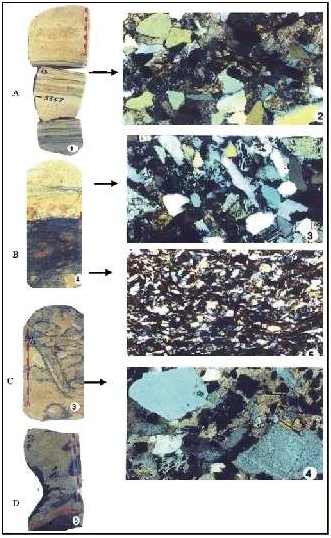
Cycle I (thickness 140m) comprises of trapwacke and red claystone and is deposited over the basaltic floor. Cycle II (thickness 180 m) is basically a fining upward sequence of medium-grained, feebly calcareous sandstone, siltstone and finally shale at the top and deposited by tidal channel in tidal flat environment. Cycle III (thickness 260 m) comprises alternations of wackestone and poorly fissile shale with occasional fossiliferous and glauconitic siltstone deposited in shallow marine environment with periodic clastic influx. Cycle IV (thickness 70 m) is characterized by a regressive facies comprising of medium- to fine-grained calcareous sandstone with kaolinitic clay clasts and has occasional burrows and argillaceous laminae (Fig. 2) and deposited by tidal channels in tidal flat environment. Cycle V (thickness 80 m) comprises of wackestone with minor shale and mark a rise in sea level and deposition in shallow marine shelf. The overall deposition environment was marginal marine (Dasgupta et al., 1999).
[Figure 2: Core photographs and corresponding photomicro-graphs of core segments of Late Cretaceous age in well CH-A-A. A: Fine grained calcareous sandstone with parallel laminae. The corresponding photomicrograph shows poor sorting and calcareous cement. B: Fine grained bioturbated sandstone with carbonaceous matter at the basal part, its photomicrograph. C: Bioturbated, fine-grained kaolinitic sandstone. The photomicrograph shows poor sorting and a few lithic fragments. D: Fine grained sandstone with claystone clasts.]
In the holostratotype the formation is divisible into four subunits: (i) The lowest unit is predominately dirty white to grey, medium- to coarse-grained sandstones with thin grey to dark grey sandstones. (ii) The second and third units consist of grey and dark grey siltstones with shales and thin limestone bands, and (iii) The top unit is dominantly shale with thin limestone bands. Hypostratotype (K-1-1) divisible into two units: (i) The lower unit in the interval of 1144-1721m consists of coarse grained arkoses / felspathic sandstones with interbeds of clays. The upper unit (800-1144m) consists of clays and thin sand bands.
Thickness is 919 m in K-1-1 and 790m in CH-1-1.
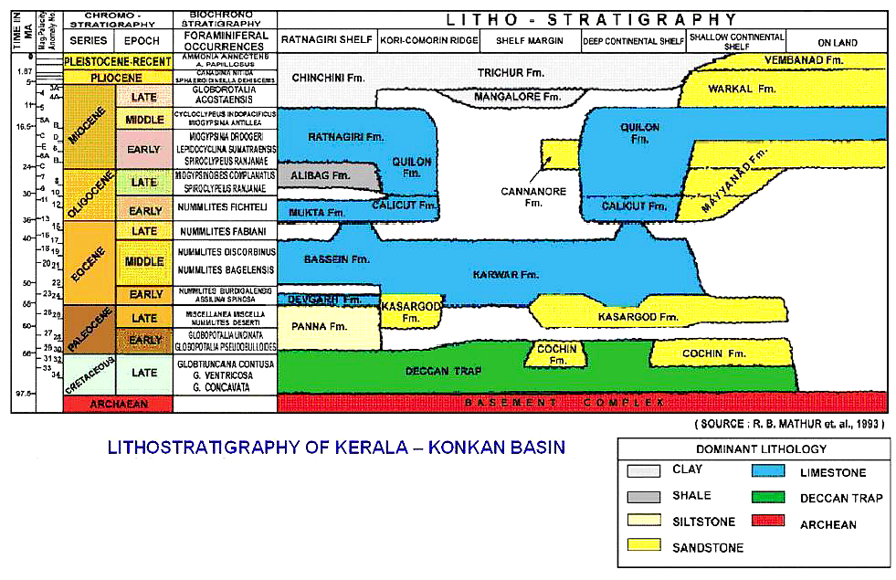
[Figure 3: Lithostratigraphy of Kerala-Konkan Basin (from dghindia.gov.in)]
Relationships and Distribution
Lower contact
Lower boundary is an unconformity overlying Basalts equivalent in age to St. Mary's Island Volcanics Fm which have been dated as 85.6 +/-0.9 Ma.
Upper contact
Upper boundary is an unconformity underlying the Kasargad Fm.
Regional extent
GeoJSON
Fossils
Morozovella pseudobulloides, M. uncinata, Rosita contuse, Globotruncana venticosa, Dicarinella concavata.
Age
Depositional setting
From foraminiferal evidences a paleobathymetry deeper than 100m can be suggested for the Santonian to Maastrichtian succession. A hiatus across KTB is recognizable. Paleocene succession was probably deposited under middle shelf environment.
Additional Information


